國立成功大學 近海水文中心
Coastal Ocean Monitoring Center, National Cheng Kung University (COMC, NCKU)
Coastal Ocean Monitoring Center, National Cheng Kung University (COMC, NCKU)
Marine Precipitation Observation
The water cycle is a crucial component of global climate variability, and its rate of change is closely related to the overall changes in the Earth’s climate system. Among the various processes that constitute the hydrological cycle, the two most important effects are evaporation and precipitation. From an atmospheric perspective, the ocean serves as the primary source of water vapor. It is estimated that approximately 90% of the freshwater flux in the atmosphere originates from evaporation over the ocean surface, while about 80% of global precipitation falls back onto the ocean. Fundamentally, precipitation is a key factor governing the global water and energy cycles, which in turn control the planet’s weather, climate, and ecosystems. Therefore, accurately and promptly understanding when, where, and how much rainfall occurs is not only essential for studying the fundamental Earth system, but also for improving weather forecasting, climate prediction, freshwater resource assessment, and natural disaster prevention. While land-based precipitation observation systems are already well established and provide reliable data from multiple observation techniques, oceanic rainfall observation remains significantly more challenging. Although various marine observation and remote-sensing techniques have been introduced, their results often differ considerably.
Traditionally, marine rainfall measurements using tipping-bucket rain gauges suffer from observation errors caused by the motion of floating platforms. In addition, when wind speeds increase, raindrops deviate from the vertical direction, resulting in incidence angle errors with respect to the rain collector opening, thereby causing further bias in measurements that depend on vertical rainfall collection. Rain gauges mounted on research or transport vessels face similar challenges—not only due to vessel motion, but also because ships cannot remain stationary for extended periods, making continuous and long-term observations impossible. While satellite-based microwave remote sensing enables large-scale and continuous rainfall estimation over the ocean, it still has limitations in detecting short-duration, intense rainfall events, which are highly variable in space and time. Moreover, the temporal resolution of satellite observations is constrained by the orbital revisit time, leading to insufficient temporal sampling for rapidly changing rainfall systems.
To address these challenges, the COMC developed an ocean rainfall observation system using a capacitance rain gauge (CRG) integrated with a data recording system, and mounted it on data buoys. Through long-term observations during Meiyu seasons, southwesterly monsoon rainfall, and typhoon rainfall periods, the system successfully recorded different types of precipitation, including stratiform rain, convective rain, and extreme rainfall events.
The Capacitance Rain Gauge (CRG) was specifically designed for marine rainfall observation on oscillating platforms. As illustrated in Figure 1, its working principle is based on measuring changes in capacitance when raindrops entering the collection chamber come into contact with the capacitance probe. The variation in capacitance is converted into a voltage signal, and the change in voltage over time is used to calculate the rainfall rate (precipitation per unit time). When the measuring chamber approaches its capacity, the accumulated water is automatically drained through a siphon tube, allowing continuous rainfall observation to proceed without interruption.

Figure 1. Internal structure of the capacitance rain gauge (Source: R.M. Young website)
In 2022, the offshore rainfall observation system was deployed at three data buoy stations — Hsinchu, Fugui Cape, and Longdong — to conduct rainfall measurements (Figure 2).

Figure 2. In 2022, the ocean rainfall observation system was deployed on three data buoy stations located off Hsinchu, Fuguijiao, and Longdong for rainfall monitoring.
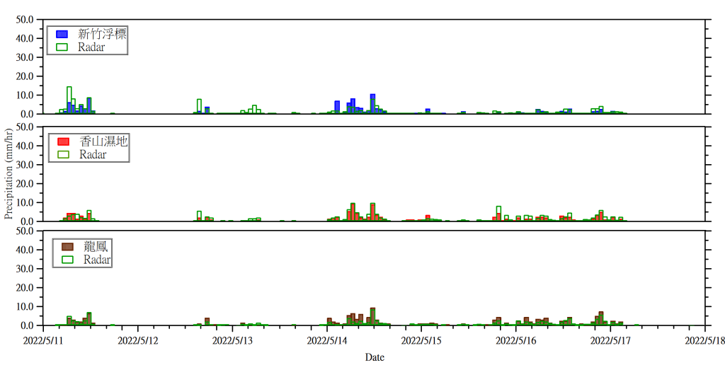
Figure 3 compares the hourly rainfall data from the Hsinchu buoy, radar, and nearby meteorological stations. The results show that the Hsinchu buoy, radar, Xiangshan Wetland Meteorological Station, and Longfeng Meteorological Station exhibit a consistent temporal pattern of rainfall events, with very similar variations in rainfall magnitude.