Coastal Ocean Monitoring Center, National Cheng Kung University (COMC, NCKU)
Rip Current
1. What is a rip current?
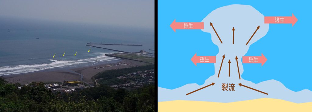
Figure 1. Schematic diagram of a rip current
2. Hazards of rip currents
Among various coastal hazards, rip currents are one of the leading causes of accidents along shorelines. According to statistics from the National Oceanic and Atmospheric Administration (NOAA), an average of about 100 people drown each year in the United States due to rip currents. Similar incidents have been reported worldwide. In the United Kingdom and Brazil, approximately two-thirds of beach-related accidents are associated with rip currents. In Asia, South Korea experienced consecutive rip current incidents from 2007 to 2009 at the well-known Haeundae Beach in Busan.
Taiwan is also significantly affected by rip current hazards. Over the past decade, media reports have documented dozens of incidents where people were swept offshore by currents, resulting in hundreds of casualties. Government agencies have begun to take these hazards more seriously. For example, on July 13, 2012, five students drowned at Shalun Beach in Tamsui, New Taipei City. Subsequent investigations suggested that a persistent rip current in the area, combined with the seaward tidal flow during low tide, contributed to the tragedy. Following this incident, the Ministry of Education issued notices to schools to strengthen awareness and safety education regarding coastal activities.
At Qieding Beach near the Erjen River estuary, another tragic event occurred on August 25, 2013, when five high school students were swept away by currents while playing in the water at noon. Despite 24 hours of search and rescue efforts, all five were confirmed dead. On the same date the following year, two junior high school students also drowned after one was swept away and the other attempted a rescue. These incidents highlight the potential recurrence of rip currents at the same location.
Rip currents possess strong energy and should never be underestimated. On May 30, 2015, at Zhudao Islet coast in Wanli District, New Taipei City, 20 kayaks carrying 39 individuals were swept offshore by rip currents. The participants were unable to paddle back due to exhaustion but were eventually rescued. This case demonstrates that not only swimmers and snorkelers are at risk, but also participants in non-motorized recreational activities.
Rip currents are characterized by high velocity, small spatial scale, and low visibility, making them extremely dangerous. Due to the complexity of their formation mechanisms, Taiwan currently lacks a reliable prediction model or warning system. As a result, it is not possible to determine when or where rip currents will occur. Furthermore, the absence of comprehensive monitoring systems makes it difficult to identify their exact location when they do occur, posing significant risks to coastal users.
3. How are rip currents monitored?
Given the hazards and risks posed by rip currents, research on this phenomenon began as early as 50–60 years ago. Various observation methods have been proposed, including drifter tracking, direct measurements using scientific instruments, and optical remote sensing (Shepard et al., 1941; Guza and Thornton, 1989; Stockdon and Holman, 2000; Turner et al., 2007). Considering the need for real-time monitoring in practice, optical camera systems are among the most feasible methods for detecting rip currents.
In recent years, Taiwan’s Central Weather Administration has initiated the development of rip current monitoring technologies and the deployment of monitoring stations. Currently, four optical monitoring stations have been established at Fulong and Shalun in New Taipei City, and Dali and Waiao in Yilan County. The distribution of these stations is shown in Figure 2.
Although rip currents are not directly visible, they produce distinct surface features when they occur. Two primary indicators are: (1) discontinuities in the surf zone (as shown in Figure 3), and (2) streaks of foam or suspended materials extending offshore (as shown in Figure 4). In addition to coastal camera observations, satellite imagery can also be used for rip current detection if the spatial resolution is sufficiently high. For example, Figure 4 shows a satellite image captured by Google Earth on December 2, 2018, at Gangkou Beach in Pingtung County, where offshore-extending suspended materials can be clearly identified on the northwest side of the beach.
By identifying these surface features, potential rip current events can be detected. Further confirmation can be achieved by analyzing characteristics such as duration, spatial distribution, and recurrence patterns.
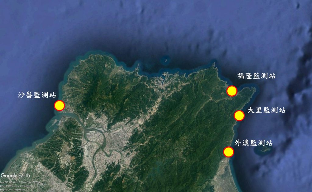
Figure 2. Schematic map of rip current monitoring station locations established by the Central Weather Administration
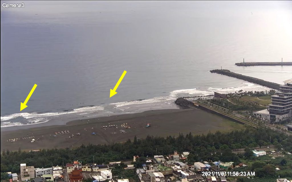
Figure 3. Observed rip current at Waiao Beach, Yilan County – discontinuity in the surf zone
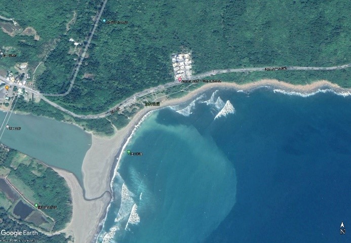
Figure 4. Observed rip current at Jialeshui Beach, Pingtung County – offshore extension of suspended materials
This research team analyzed high-resolution satellite imagery from 2013 to 2017 provided by the National Central University Center for Space and Remote Sensing Research. The study area covered beach-type coastal regions surrounding the main island of Taiwan. The results indicate that most rip current cases are concentrated at 43 beaches, including well-known recreational hotspots such as Fulong Beach, Waiao Beach, Yuguang Island Beach, and Da’an Coastal Recreation Area (as shown in Figure 5).
In addition, the research team obtained a full year (2022) of video data from the Waiao rip current monitoring station operated by the Central Weather Administration. Statistical analysis of rip current duration shows an average duration of approximately 3.8 hours, although there is considerable variability among cases, with the shortest lasting less than 1 hour and the longest up to 10 hours. The analysis also reveals that multiple rip channels can occur simultaneously at the same beach. Furthermore, due to the strong influence of coastal topography on rip current formation, the width of rip currents varies significantly by location. Overall, most rip currents have a width ranging between 20 and 80 meters.
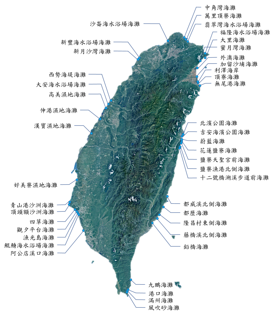
Figure 5. Potential rip current occurrence zones around Taiwan
4. Observational results of rip currents
Rip currents are hidden hazards in the ocean that pose risks to recreational users and marine professionals. However, research on rip currents in Taiwan remains limited, and most case data are derived from media reports. Due to the lack of real-time field measurements during incidents, these data inherently contain uncertainties. Therefore, establishing a comprehensive database of rip current cases is essential.
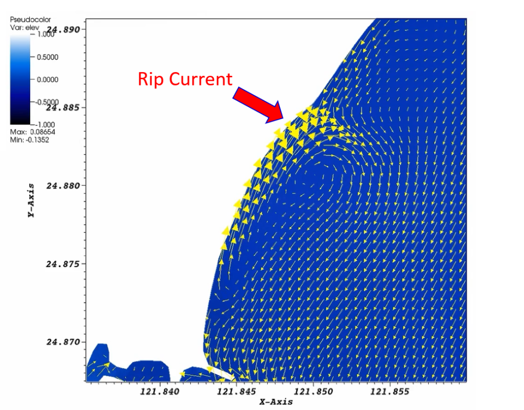
With advances in technology, numerical models for ocean wave and current prediction have significantly improved in both temporal and spatial resolution, making them capable of simulating nearshore rip current dynamics. This research team has applied coupled wave–current models, including SCHISM-WWM and CMS-FLOW/WAVE, to simulate rip current events at Waiao Beach in Yilan and Yuguang Island Beach in Tainan (as shown in Figures 6 and 7). The results demonstrate good agreement with observed hydrodynamic conditions, confirming the reliability of these models.
In summary, long-term observations and data collection, combined with numerical modeling, are essential for understanding rip current characteristics, advancing research on their formation mechanisms, and establishing early warning systems.
Finally, if one encounters a rip current, it is important to remember three key principles: “stay calm,” “float,” and “swim sideways.” In other words, remain calm and do not attempt to swim directly against the current. Instead, float and move with the current or swim parallel to the shoreline until exiting the rip current zone, and then return safely to shore.
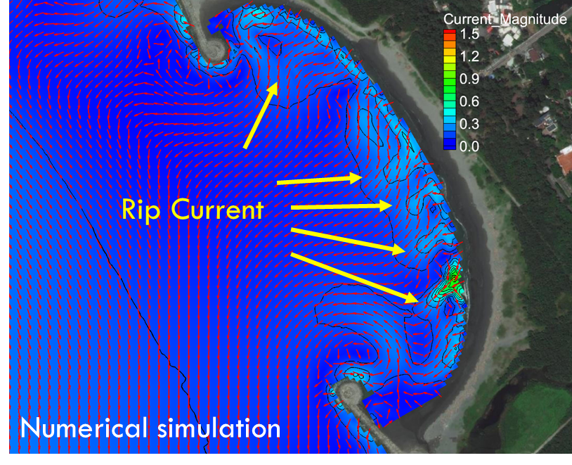
Figure 6. Rip current simulation at Yuguang Island Beach using the CMS-FLOW/WAVE coupled wave–current model